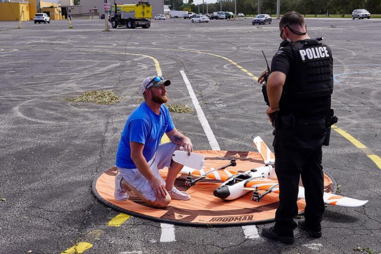
Matthew Davis, a student at Embry-Riddle Aeronautical University, recognized the power and effectiveness of drones in disaster recovery efforts after being hired by Sensys Technologies Corporation after interning.
So when Hurricane Milton recently flooded areas near Embry-Riddle University’s Daytona Beach campus with debris and flooded roads, he immediately joined the Censys team to proactively assess storm damage in the city of South Daytona.
“It was scary to see the flooding and the damage,” said Davis, a senior unmanned aircraft systems (UAS) student from nearby Ormond Beach. But, “I was very happy to be able to go out and do something useful.”
In the aftermath of Hurricanes Helen and Milton, high-tech unmanned aerial systems, or drones, have become the eyes of first responders navigating flooded terrain, closed roads and other storm damage. This technology is being deployed not only after powerful storms, but also to capture data to prevent future flooding.
Founded by Embry-Riddle alumni and based in the Micaplex in Research Park on Embry-Riddle’s Daytona Beach campus, Censys uses its high-tech Sentaero 5 drone to locate flooded areas in south Daytona. It flew over the sky and collected data for a post-storm assessment. conditions, infrastructure damage, debris accumulation, flood mapping, and potential for water main breaks.
Embry-Riddle student Matthew Davis is a UAS pilot with Censys Technologies Corporation and was part of a team assisting the City of South Daytona with post-storm assessments following Hurricane Milton. (Photo: Embry‑Riddle/Censys Technologies Corporation)
Developed by Censys, Sentaero 5 is equipped with sensors, cameras, and collision avoidance systems that allow it to collect critical data over large areas more quickly and efficiently than traditional methods. It also qualifies for a “beyond line of sight” (BVLOS) exemption from the Federal Aviation Administration. BVLOS capabilities allow UAS to fly beyond the visual range of the operator and cover and collect data from remote locations.
After Hurricane Helen hit the Florida Gulf Coast in September of this year, the Censys team completed a five-day post-storm mission mapping hard-hit areas from the Panhandle to south of Tampa.
They worked with the Florida Department of Transportation to understand road closures, debris accumulation, and damaged infrastructure. Censys’ two mobile UAS teams deployed to the region were comprised of four Embry-Riddle graduates.
“Being there in the immediate aftermath of the storm and being able to contribute to that recovery process was truly eye-opening,” said Joseph, a 2021 Embry-Riddle graduate and now chief UAS pilot at Censys. Clement said.
Adam Zirkelbach, director of marketing for Censys, said the company received Special Government Interest (SGI) clearance from the FAA, allowing the team to conduct beyond visual line of sight flights. This allows Censys crews to fly their Sentaero 5 drones farther and faster.
“Providing the post-storm mapping response to Hurricane Helen was a whirlwind experience,” said Larry L. Leovan, Censys government sales director and Embry-Riddle alumnus who worked on the project. “In total, we were able to capture 499 linear miles of road, 20,507 images, and 501 GB worth of data in five days.”
Additionally, Censys is working with Flagler County to use Sentaero 5 drones to survey coastal erosion before and after storms.
Protecting communities from future floods
Embry-Riddle students are also working to use UAS to alleviate flooding in their communities and reduce damage from future storms.
James “Tyler” Diehl, a senior Unmanned Aircraft Systems (UAS) student, participated in a project using UAS and LiDAR data to help evaluate environmentally friendly stormwater solutions in Cape Canaveral, Florida. LiDAR stands for Light Detection and Ranging and uses pulsed laser light to measure distance and recreate 3D objects.
Eagle alumni Larry L. Leovan (left) and Joseph Clement (right) of Censys Technologies Corporation were part of a team that used UAS to map 500 miles of the Florida Gulf Coast after Hurricane Helen.
“Tyler modeled urban flooding before a hurricane,” said Dr. Nicholas “Dan” Macchiarella, professor of aeronautical science. “The modeling was based on LiDAR data collected from drones, and we used that LiDAR data to model flooding and help build infrastructure to alleviate flooding.”
This project is funded by a National Science Foundation grant in collaboration with Stetson University and the City of Cape Canaveral.
“UAS is essential to any flood mitigation toolbox as a valuable resource for gathering accurate models through LiDAR and photogrammetry,” said Diehl. “These models are needed to accurately predict future weather impacts and enable low-cost simulation and iteration of flood mitigation strategies.”
Dr. Jason M. Evans, Stetson University Research Professor of Environmental Science and Executive Director of the Institute for Water and Environmental Resilience, said he hopes to collaborate on more UAS projects to help other flood-prone communities. He said he was looking forward to it.
“The detailed imagery and terrain information that can be collected by UAS provides capabilities for flood risk modeling that were unimaginable just a few years ago,” Evans said.
Macchiarella said these real-life experiences provide valuable hands-on learning opportunities for Embry-Riddle University students.
“For many years, students have been using unmanned aircraft systems to remotely detect cities and critical infrastructure before and after disasters,” he said. “This data collection and analysis helps us complete classroom learning meaningfully and helps our community.”
Category: Aviation | Unmanned Systems


